

Skip to main content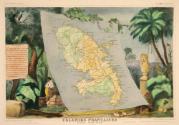
Cartographer
Victor Levasseur
(French, active 1838 – 1854)
Publisher
A. Combette
(French)
Author
Philippe Burty
(French, 1830 – 1890)
Datec. 1856
MediumEngraving with hand coloring
DimensionsComposition: 10 3/8 × 16 1/8 in. (26.4 × 41 cm)
Sheet: 14 1/4 × 20 3/4 in. (36.2 × 52.7 cm)
Credit LineThe Beinecke Lesser Antilles Collection of Hamilton College
Object number1971.59
Not on view
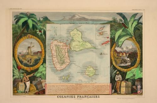
DescriptionMap depicting the archipelago of Guadeloupe, known as Karukera by the local population. On the left, a man stands beside a crate of sugar, a yellow barrel of coffee, and a crate of girofle. A cartouche depicts two slaves standing with spades in front of a windmill. Portraits of Lethière and Coupenon embellish the cartouche frame. On the right, there is cotton, rubber, and cacao. An enslaved man holding a spade stands behind a colonizer. The cartouche depicts a natural disaster scene with damaged infrastructure and loss of human life.
Collections
Additional Details
Exhibition History
2007
Clinton, NY (Fred L. Emerson Gallery, Hamilton College). "Beinecke Collection," June 21 - September 16, 2007.
Clinton, NY (Fred L. Emerson Gallery, Hamilton College). "Beinecke Collection," June 21 - September 16, 2007.
Provenance
1971: Hamilton College, by gift of Walter Beinecke, Jr.
Published References
Hough, Samuel J. and Penelope R.O. Hough, THE BEINECKE LESSER ANTILLES COLLECTION AT HAMILTON COLLEGE: A CATOLOGUE OF BOOKS, MANUSCRIPTS, PRINTS, MAPS, AND DRAWINGS (Trustees of Hamilton College, Clinton, NY, 1994), 326, catalogue no.C30.
Inscribed
[Note: In the original 19th century French, there are a few minor misspelled words and accents missing, which have been corrected for clarity in the transcription.]
« Statistiques »
L’Île de la Guadeloupe, l’une des plus considérables de l’Archipel des petites Antilles est
nommée par les naturels Karukera. Placée sous le ciel brulant des tropiques elle éprouve de fortes chaleurs que les vents de mer qui soufflent tout le jour rendent supportables. L’humidité y est très grande. Dans la Grande Terre l’eau des pluies s’amasse sur quelques points et exhale des miasmes qui corrompent l’air. Les côtes exposées à l’action salutaire des vents d’Est jouissent d’un air pur et sain. Pendant les mois de juillet, août et septembre, époque des grandes pluies, la Guadeloupe est exposée à de terribles ouragans qui causent d’affreuse ravages. Le sol se trouve séparé en deux îles par un petit bras de mer appelé Rivière Salée. La Guadeloupe proprement dite est à l’ouest et renferme dans le sein de ses montagnes un volcan appelé la Soufrière. La partie située à l’Est est plate et formée d’une terre grasse et fertile. Les productions végétales sont le
sucre, le café, le coton, le cacao, la cannelle, la girofle, la muscade et généralement tous les produits des tropiques. Le gouvernement colonial comprend aussi les îles Marie-Galante, la Désirade, les Saintes et la partie française de L’Île St. Martin. La Guadeloupe se divise en trois arrondissements, six cantons et 29 commines. LA BASSE TERRE est le chef-lieu de la Colonie et le siège du gouvernement. Sa population est de 5,500 aimes. LA POINTE À PITRE située à l’Ouest de la Grande Terre, en contient 15,000. Elle fut détruite en février 1842 par un tremblement de terre. La population générale de la Guadeloupe et dépendances s’élève à 136,000 habitants dont 400,000 Libres et 90,000 Esclaves avant l’affranchissement qui fut la conséquence de la Révolution de Février. La Distance de la Guadeloupe à la Côté de France est d’environ 2,600 lieues Marines ou 14,430 kil. On évalue le temps de la traversée de la Guadeloupe à la France à 40 jours.
“Statistics”
The island of Guadeloupe, one of the most considerable of the archipelago of the Lesser
Antilles, is named by the natives Karukera. Located under the blazing tropical sun, it experiences strong heat which the sea breezes that blow throughout the day make bearable. The humidity is very high here. In the Grande Terre, the rain water accumulates on a few points and releases miasma that contaminates the air. The coasts exposed to the East winds enjoy pure and healthy air. During the months of July, August, and September, when there are heavy rains, Guadeloupe is exposed to terrible hurricanes that cause awful destruction. The earth is separated into two islands by a small branch of the sea called Rivière Salée. Guadeloupe proper is to the west and contains within its mountains a volcano called La Soufrière. The eastern part is flat and made up of rich fertile soil. Vegetable productions include sugar, coffee, cotton, cocoa, cinnamon, cloves, nutmeg and generally all the products of the tropics. The colonial government also includes the islands of Marie-Galante, la Désirade, les Saintes, and the French part of L’Île St. Martin. Guadeloupe is divided into three districts, six administrative districts, and 29 communes. The Basse-Terre is the administrative center of the colony and the seat of the government. Its population is 5,500. Point à Pitre, located west of Grand Terre, includes 15,000. It was destroyed in February, 1842 by an earthquake. The general population of Guadeloupe and its dependencies amounts to 136,000 inhabitants, including 400,000 Free and 90,000 Slaves before the emancipation which was the consequence of the February Revolution. The distance from Guadeloupe to the coast of France is around 2,600 nautical miles, or 14,430 kilometers. The time to cross from Guadeloupe to France is an estimated 40 days.
Victor Levasseur
Date: c. 1842
Medium: Engraving with hand coloring
Object number: 1971.38
René Zuber
Date: October 1937
Medium: Vintage ferrotyped gelatin silver print
Object number: 2024.21.235
Unknown artist
Date: mid 19th-mid 20th century
Medium: Dark brown glazed terracotta
Object number: INV.701
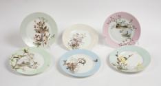
Flora Winegar Brigham
Date: 1885
Medium: Hard paste porcelain with enamel decoration
Object number: 1997.10.1.1-6
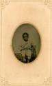
Unknown artist, American
Date: 1865-1875
Medium: Tintype
Object number: 2023.4.1
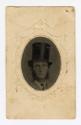
Unknown artist, American
Date: 1860-1870
Medium: Tintype mounted in paper cartouche
Object number: S2023.1.58
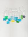
Tony Feher
Date: 1996
Medium: Plastic bottles, water, food dye, wire and rope
Object number: 2012.3.4
Renée Stout
Date: 2008-10
Medium: Acrylic, latex paint, spray paint, plastic rhinestones, wood, glass, metal, varnish, collage, and found objects
Object number: 2016.2
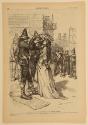
Thomas Nast
Date: published March 6, 1875
Medium: Wood engraving on newsprint
Object number: 2019.13.273
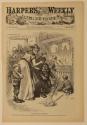
Thomas Nast
Date: published March 6, 1875
Medium: Wood engraving on newsprint
Object number: 2019.13.274
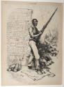
Thomas Nast
Date: published October 28, 1876
Medium: Wood engraving on newsprint
Object number: 2019.13.346